The Île-de-France Mobilités stop repository
Île-de-France Mobilités receives the theoretical offer from85 operators in Île-de-France, on the 2000 lines serving a total of 40,000 stops. So, to harmonize and perpetuate the coding of the data received, two repositories have been set up by Île-de-France Mobilités: a line repository and a stop repository. In this article, we'll take a look at this second repository and the datavisualization of it offered on PRIM.
In fact, on the PRIM platform, the "stop repository: GIS file" dataset offers all the objects in the Île-de-France stop repository.
This dataset is updated daily and published under the open license Open Database License (OdBL).
For more information, about Île-de-France Mobilités' stop and line referentials, please feel free to consult this documentation.

Une datavisualisation du référentiel des arrêts d'Île-de-France Mobilités
Within the "Référentiel des arrêts : fichiers SIG" dataset, in the "Map" tab, a datavisualization of Île-de-France's transport repositories is available. We've also integrated it below:
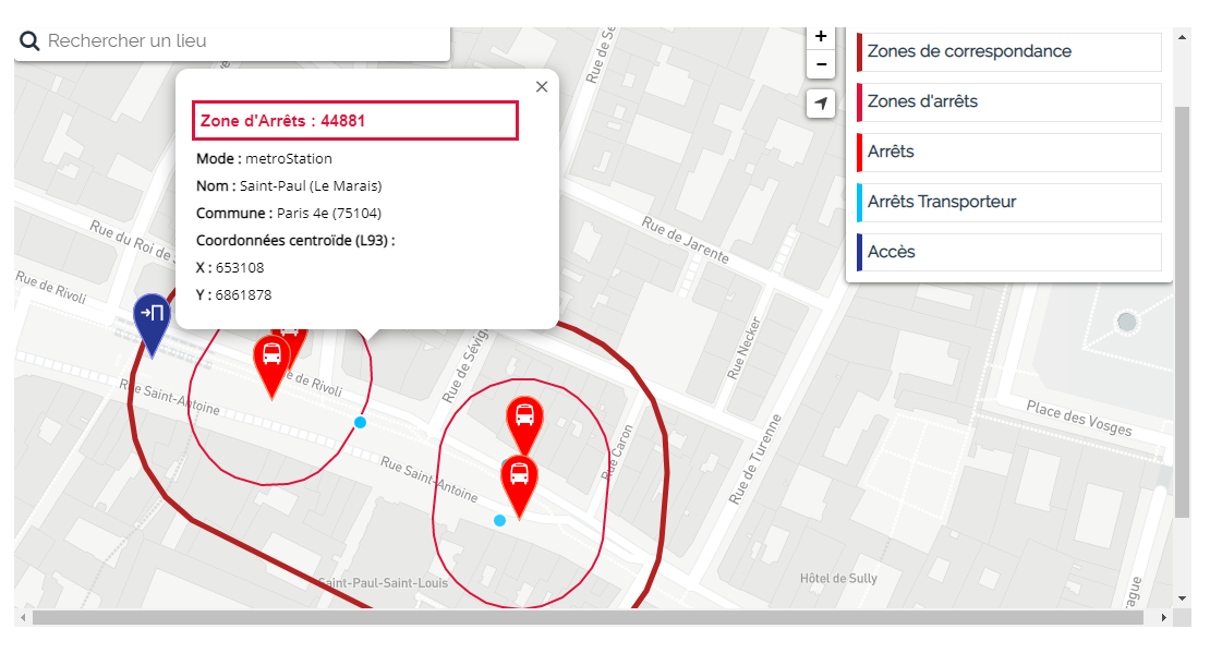
It is possible to parameterize the display of the above datavisualization by selecting with the tool the objects in the stop repository you wish to display:
- The carrier stops, represented by light blue dots which are only displayed above a certain zoom level: "field" stopsdeclared by a carrier and which can take several forms.
- Thestops, represented by red bubblesaround a"bus" pictogram: "community"stops shared by several carriers and built from their information.
- The stop zones delimited by a fine bright red line: single-mode zones based above allon commercial (and geographical) consistency and known to the public under the same commercial name.
- The connection zones delineated by a thick red-bordeaux line: multimodal zones where pedestrian connections between stops are implicit (reasonable pedestrian travel time).
- The accesses represented by dark-blue bubbles displaying a "door" pictogram: compulsory crossing points that a passenger must use to be able to access the stops in one or more stop zones (entry) or exit this/these zone(s) (exit).
Clicking on the various objects in the datavisualization displays tooltips. For each object, a certain amount of additional information is provided:
- For the carrier stop: The name of the stop, its identifier, its supplier, the communeand thezone to which it belongs, its geographic coordinates (Lambert 93), the means of transport stopping there, a value specifying whether it is accessible to wheelchair users and if it has a audio and/or visual device.
- For the stop: The same data as for the carrier stop with the exception of the supplier.
- For stop areas: the name of the stop, itsidentifier, its commune, its geographic coordinates (Lambert 93) and the transport mode used in this stop area.
- For transfer zones : The same data replacing the mode of transport with the principal mode of transport, since the transfer may be between different modes of transport.
- For access: The provider of the access, the name of the access, itsidentifier, its geographic coordinates (Lambert 93) and whether it is anentry, an exit, or both
You can export this dataset "Stop repository: GIS files" and reuse it in your projects. We'd be delighted if you could share your data reuse with the "PRIM community". Don't hesitate to send it to us via the #data-reuses channel of our "Slack" of the "PRIM community".