Description of Île-de-France Mobilités' GTFS
On the PRIM platform, Île-de-France Mobilités makes a GTFS (General Transit Feed Specification) available to data reusers, via the dataset "Scheduled timetables on public transport lines in the Ile-de-France (GTFS Datahub)". It is updated three times a day at 8am, 1pm and 5pm.
It is a set of files describing the theoretical transport offer in the next 30 days,proposed by all operators in the Île-de-France Region on all means of public transport (trains, RER, metros, streetcars, buses and coaches). In fact, GTFS includesspatial data from the line and stop referential (stops, lines, directions, connections) and timetable files presenting the theoretical time of passage of a line at a specific stop.
Note that,the GTFS does not include real-time information. This set of files is based exclusively on the theoretical offer comunicated by carriers.
This data specification (GTFS) enables the transport organizing authority Île-de-France Mobilités to publish its transport data in a format that can be used by a large variety of software applications.
For more information about this data format, please feel free to consult this documentation.
Text files contained in the GTFS
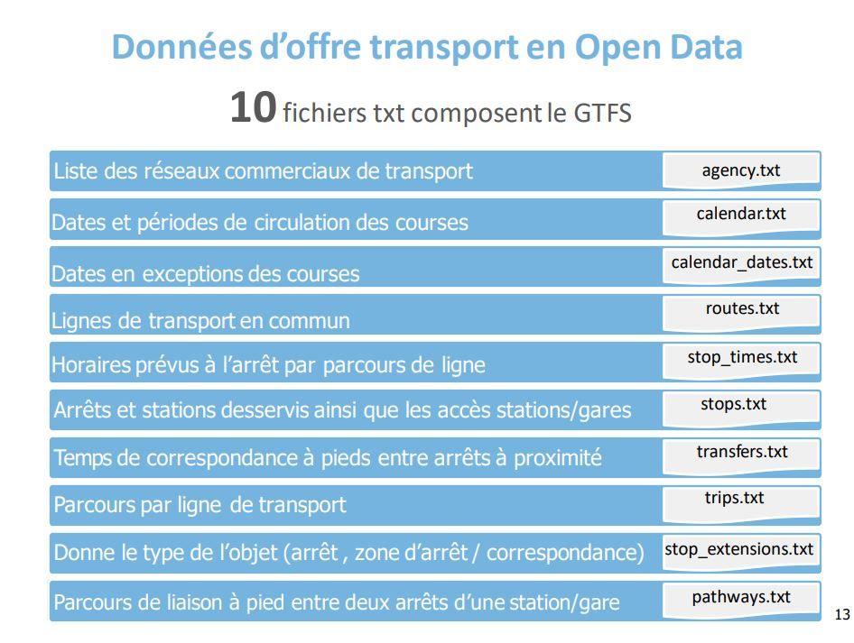
In order to depict the theoretical transport offer over the next 30 days, the GTFS cross-references ten txt files, all of which you can download through the dataset export "Scheduled timetables on Ile-de-France public transport Lines (GTFS Datahub)" available on PRIM.
The ten files are organized as follows:
- The list of commercial transport networks "agency.txt"
- The Lines of public transport"routes.txt"
- The stops and stations served, as well as station/station access "stops_txt"
- The routesby Lines transport "trips.txt"
- The object types (stop, stop area, transfer area, etc..) "stop_extensions.txt"
- The walking link between two stops at a station/train station "pathways.txt"
- The dates and periods for running races "calendar.txt"
- The dates in exception for races"calendar_dates.txt"
- The scheduled stop times per Lines route "stop_times.txt"
- The walking connection times between nearby Stops "transfers.txt"
For more information about Île-de-France Mobilités' transport offer data in GTFS format, we invite you to consult the dedicated documentation available on the PRIM platform.
A datavisualisation of the geographical components of the GTFS
The PRIM platform offers a visualization of the geographical data comprised by the GTFS (from the Stops and Lines referentials). It is a map allowing you to display the Lines and Stops of the Ile-de-France network. Following is a screenshot of this map:
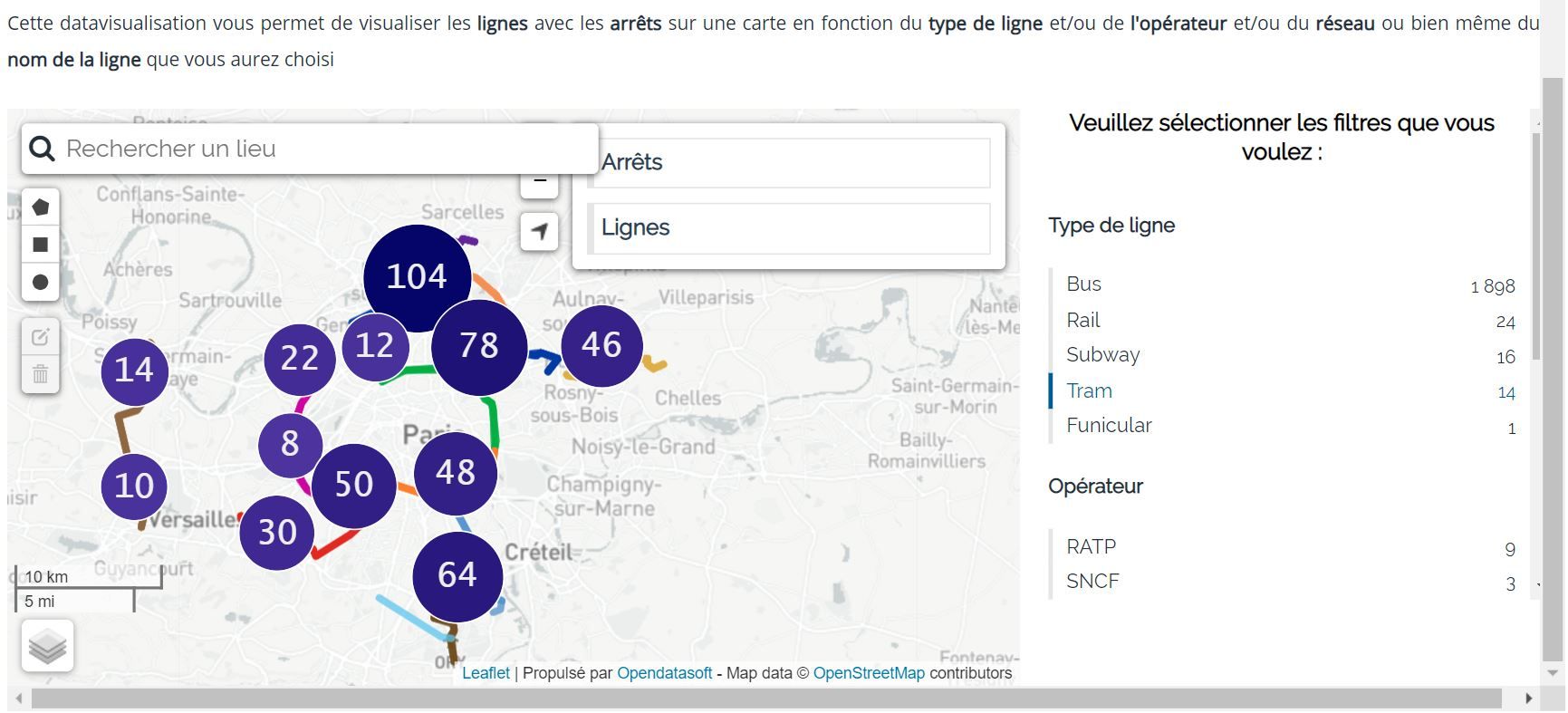
Feel free to view this datavisualization in format "iframe" within the "Map" tab of the "Scheduled timetables on public transport Lines in Ile-de-France (GTFS Datahub)" dataset. In fact, the "iframe" format of the datavisualization allows you to parameterize it in order to display only the information that interests you. Note that in order to access the datavisualization from the dataset's "Map" tab, you must imperatively be logged into your PRIM platform account. Otherwise, the map will not be displayed.
When setting up the datavisualization, you can choose to display only Lines, only Stops or both combined. You can also filter the display according to the network(Transilien, Noctilien, etc.), the types of transport (bus, train, metro, streetcar, etc.) and the operator that operates the line or serves the Stops. Finally, it is also possible to display only a single Lines and the Stops it serves by using the search bar available within the datavisualization. To do this, simply select the first letter or number of the line you're looking for from the first drop-down list offered, then find it in the second drop-down list taking into account the parameter previously entered.
Clicking on a line opens a tooltip displaying: the identifier of this line in the GTFS of Île-de-France Mobilités, the network to which it belongs, the operator offering this transport offer and a link to the documentation available concerning this line.
Similarly, clicking on a specific stop on the map, displays the following information: the identifier of the stop in the Île-de-France Mobilités GTFS, its commune, the transport zone to which it belongs (from 1 to 5) and theaccessibility to the stop for wheelchair users.
A dataset subject to the Mobility License
The dataset "Scheduled timetables on Ile-de-France public transport Lines (GTFS Datahub)", the Mobility License which involves a connection prerequisite. This means being registered on the PRIM portal and being logged into your account to be able to export the dataset and/or have access to the datavisualization.
For more information about the Mobility License go to the "Licenses" page of the PRIM portal and/or visit the Mobility Factory website, which publishes the Mobility License as an open access publication.
The reuse of datapublished under the Mobility License remains easyfor PRIM platform users and very strongly encouraged by Île-de-France Mobilités. So, please feel free to export this dataset "Scheduled timetables on public transport lines in Ile-de-France (GTFS Datahub)" and reuse it as much as you like. We would be delighted if you could let the "PRIM community" benefit from your data reuse. Please feel free to send it to us on the #data-reuses channel of our "Slack" "PRIM community".